NISAR Launches Successfully: India and USA Start a New Journey to Study Earth Together
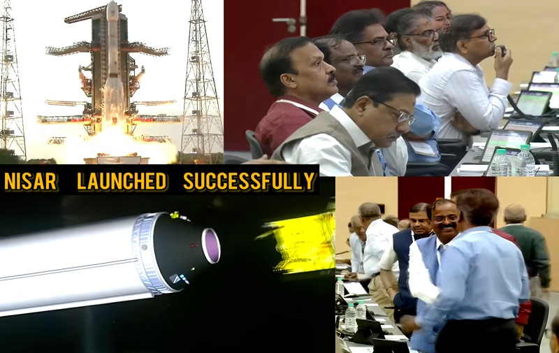
A new chapter in global space exploration began today with the successful launch of the NASA-ISRO Synthetic Aperture Radar (NISAR) satellite. Blasting off aboard India’s GSLV-F16 rocket from the Satish Dhawan Space Centre in Andhra Pradesh, NISAR marks the first major Earth science mission jointly developed by the Indian Space Research Organisation (ISRO) and the United States’ National Aeronautics and Space Administration (NASA). This 2,392-kg satellite now orbits Earth at an altitude of 743 km in a sun-synchronous path, ready to provide unmatched data about our planet. The launch went smoothly, drawing cheers from mission teams and scientists on both sides of the globe.Why NISAR Stands OutWhat makes NISAR different from other Earth-monitoring satellites is its dual-frequency radar system a world first. It is equipped with two kinds of Synthetic Aperture Radar (SAR): the L-band radar developed by NASA and the S-band radar built by ISRO. Both radars work together on one satellite platform to deliver high-precision, all-weather, day-and-night imaging of Earth’s surface. NISAR is so sensitive that it can detect ground movements as small as one centimeter. It scans wide areas—up to 242 km at once—and returns to observe the same regions every 12 days. This consistency helps scientists track changes like never before.Designed to Help the PlanetMore than just capturing beautiful images from space, NISAR will play a vital role in protecting people and the environment. It can detect early signs of natural disasters such as earthquakes, landslides, and volcanic activity. It will monitor melting glaciers, rising sea levels, and forest cover, all crucial in the battle against climate change. Farmers will benefit too NISAR can help monitor soil moisture and crop conditions, enabling better planning and smarter farming. It will also help in tracking river systems, flooding, and erosion, offering valuable data for water and land management. Building a satellite with two radar systems that operate at different frequencies and have separate instruments is no small task. One of the key highlights is the 12-meter wide antenna built by NASA, which unfolds in space and collects data from both radars. Combining this complex hardware into one functioning spacecraft took over a decade of collaboration between the two space agencies. This is a strong example of how international cooperation can lead to great scientific achievements.India’s Strong ContributionIndia played a leading role in this joint venture. ISRO developed the S-band radar at the Space Applications Centre in Ahmedabad and designed the satellite's main structure at the U.R. Rao Satellite Centre in Bengaluru. The entire launch was handled by ISRO using its GSLV-F16 rocket, and the country invested over ₹469 crore in the project. This mission shows India’s growing leadership in global space exploration and its increasing ability to deliver complex and advanced space technology.NASA and ISRO: A Vision for the FutureFor NASA, NISAR is among its most advanced Earth-observation missions. With the L-band radar capable of seeing through forests and the S-band radar picking up fine surface details, NISAR will provide a multi-layered view of Earth. The satellite will allow scientists to better understand tectonic shifts, groundwater movement, and ecosystem changes. Officials from both NASA and ISRO have praised the partnership, calling NISAR a milestone in Earth science and international space collaboration. NISAR’s successful launch is more than just a technical achievement it’s a symbol of unity, innovation, and shared responsibility. It will help us learn more about our planet and respond more effectively to environmental challenges. As NISAR begins its mission in space, the world watches with hope. It promises to be our eye in the sky, helping us care for the Earth better and preparing us for a smarter, safer future.