"Dream, Dream, Dream! Conduct these dreams into thoughts, and then transform them into action."
- Dr. A. P. J. Abdul Kalam
"Dream, Dream, Dream! Conduct these dreams into thoughts, and then transform them into action."
- Dr. A. P. J. Abdul Kalam
30 Jun 2026
On June 27, 2026, an IndiGo Airbus A320 quietly made aviation history as it descended onto the runway at Udaipur. To passengers onboard, it was an ordinary landing. But behind the scenes, something extraordinary was happening.
Instead of relying on the traditional ground-based radio equipment that has guided aircraft for decades, the aircraft completed its approach using GAGAN (GPS Aided GEO Augmented Navigation)—India's indigenous satellite-based navigation system.
Conducted under the supervision of the Directorate General of Civil Aviation (DGCA), the landing marked the first time a commercial passenger jet in India successfully landed using GAGAN. While smaller turboprop aircraft had previously demonstrated the technology, this was the first successful operation involving a larger jet aircraft like the Airbus A320.
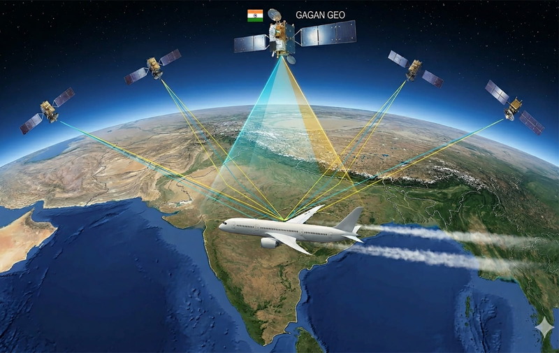
Developed jointly by the Indian Space Research Organisation (ISRO) and the Airports Authority of India (AAI), GAGAN is India's Satellite-Based Augmentation System (SBAS). Unlike GPS, GAGAN doesn't determine an aircraft's position independently. Instead, it enhances existing GPS signals by correcting their errors in real time, dramatically improving their accuracy and reliability.
The system broadcasts its corrections through ISRO's communication satellites GSAT-8 and GSAT-10, which continuously cover the Indian subcontinent. It's easy to confuse GAGAN with NavIC, India's regional navigation system. However, the two serve different purposes.
NavIC provides independent positioning, similar to GPS. GAGAN improves GPS accuracy, making it precise enough for critical aviation operations like aircraft landings.
The GPS in smartphones is accurate enough to help people find restaurants or navigate city streets. But landing a passenger aircraft weighing over 70 tonnes demands far greater precision. The biggest challenge lies in the ionosphere—an electrically charged layer of Earth's upper atmosphere.
As GPS signals pass through this layer, they become distorted. These distortions are particularly severe over India because the country lies beneath the Equatorial Ionisation Anomaly, one of the most difficult regions in the world for satellite navigation. Without correction, even tiny errors can become unacceptable during aircraft landings, especially in poor visibility.
To eliminate these errors, GAGAN relies on a sophisticated nationwide network. Fifteen precisely surveyed ground reference stations spread across India continuously monitor GPS signals. Since the exact position of every station is known to within centimetres, any difference between the GPS reading and the station's actual location reveals the GPS error.
These corrections are sent to a central control facility, which then transmits them to the GSAT satellites orbiting above the equator. The satellites instantly broadcast the corrected information back to aircraft across Indian airspace. More importantly, GAGAN continuously evaluates the quality of its own guidance. If the signal becomes unreliable for any reason, the system alerts pilots within seconds, ensuring safety remains uncompromised.
The IndiGo aircraft performed what aviation experts call an LPV (Localiser Performance with Vertical Guidance) approach. In simple terms, this provides pilots with both horizontal and vertical guidance, very similar to the highly accurate Instrument Landing System (ILS) installed at major airports.
The difference is remarkable. ILS requires expensive ground-based radio transmitters and antennas at every airport. GAGAN delivers comparable guidance directly from space, eliminating the need for costly infrastructure at smaller airports. This has enormous implications for India's rapidly expanding regional aviation network.
Many smaller airports currently lack advanced landing systems because installation and maintenance costs are high. GAGAN can bring precision approaches to these airports using infrastructure that already exists in orbit.
The result could be:
Safer landings during poor weather
Fewer flight diversions and delays
Lower infrastructure costs
Better connectivity to remote regions
More efficient air traffic management
India now joins a select group of nations with indigenous satellite-based augmentation systems. What makes GAGAN especially significant is that it has proven its capability over the challenging equatorial skies, where satellite navigation is notoriously difficult.
.jpeg)
I have a Masters in Literature and a knack for spotting the silver lining! When I’m not chasing good news, you’ll find me nurturing my farm or lost in a good book.